Why are shipwrecks important?
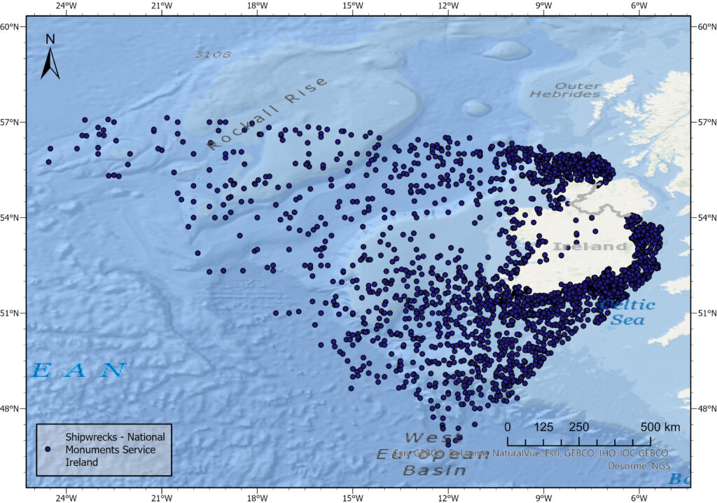
Shipwrecks not only provide unique opportunities to investigate relatively unaltered archaeological deposits, but they are also linked to environmental pollution threats. Moreover, as they are often hotspots for marine biodiversity, they attract fishers and sport divers. Wrecks constitute our common underwater cultural heritage, and some of them are commemorated as underwater war graves. According to UNESCO there are 3 million shipwrecks around the world, and they are often densely distributed in semi-enclosed, relatively shallow and busy seas. For example, The Baltic Marine Environment Protection Commission estimates around 10000 shipwrecks in the Baltic Sea, while around 18000 shipwrecks reside around Ireland per the Underwater Archaeology Unit in Dublin (Figure 1). The sheer scale of shipwreck occurrence and the complexities entailed by their presence at the seabed create a challenge for marine spatial planning and heritage management (Firth, 2018). Further complexity is added by the fact that most known sites have been virtually unresearched, while new ones are discovered every year.
Like terrestrial archaeological sites, submerged shipwrecks undergo deterioration. Sediment erosion and accumulation due to currents and storms at shipwreck sites may cause significant damage to their fragile structures, already weakened by the corrosive action of seawater. To understand which shipwrecks are prone to accelerated deterioration and support their management, the influence of such local environmental factors must be understood. On top of that, anthropogenic influences like fishing and illegal salvage operations can further disrupt underwater sites, so it is important to determine which shipwrecks are exposed to human impacts. These environmental and anthropogenic factors can be investigated through the assessment of so-called post-depositional site formation processes.
Multi-method characterisation of shipwreck sites in the Irish Sea – a PhD project
Jan’s PhD project finished in April 2022 aimed to extend the knowledge of the influence of combined sediment- and hydro- dynamic processes on the in-situ preservation of fully submerged, historic wreck sites. The study used multibeam echosounder data of very-high, centimetric resolution repeatedly collected over twelve metal-hulled shipwrecks resting in the Irish Sea. Additional geological and hydrodynamic data were derived from sediment grabs, shallow-seismics and an oceanographic model. After creating 3D models of the sites and mining regional oceanographic data, computational fluid dynamic simulations were used to further understand site deterioration. This multi-disciplinary combination of data and developed workflows were applied in three complementary research papers corresponding to the objectives set out in the thesis.
Detailed seabed characterization around shipwrecks
The first study aimed at detailed characterization of the sites and mapping of geomorphological features surrounding them (Majcher et al., 2020). Apart from local geomorphological features like dunes migrating through some sites, shipwrecks are often associated with the development of seabed scour. Wrecks are large objects which locally modify water flow patterns. This in turn causes seabed erosion or scour, developing scour holes occasionally several meters deep and hundreds of meters long, as shown in Figure 2. Seabed scour, well-known to offshore and inland water engineers can significantly influence site stability (Quinn, 2006), and therefore a methodology for objective delineation of such geomorphological features was developed.
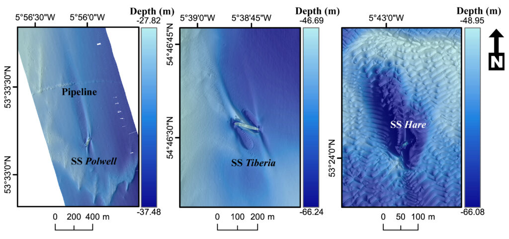
(From Majcher et al., 2020).
Recording seabed changes around wrecks
The temporal and spatial scales at which seabed change occurs around wrecks remain largely unresearched. To fill this gap, for the second study the wrecks were surveyed multiple times and additional legacy data were obtained allowing for investigating weekly, annual, multi-annual and decadal seabed changes (Majcher et al., 2021). This has significantly expanded the number of case-studies reported for shipwreck site evolution, providing new knowledge not only for archaeological research, but also analogies to sub-sea engineering. Results showed a large variability between the individual sites, even though they are all located in the same, semi-enclosed, tidally-dominated shelf sea. An example of a 3D model showing changes at one of the sites is shown in Figure 3 with some extreme topographic changes in direct proximity to the wreck (up to nearly 5 m elevation change). Local geological and oceanographic parameters, like sediment substrate and current magnitude were determined as significant factors influencing site evolution. One of the studied wrecks was observed to be affected by intense bottom trawling, with so-called trawl-scars directly intersecting the shipwreck, which is a proof that some sites might be affected by anthropogenic impacts. This type of uncontrolled interaction of heavy fishing equipment with a wreck may cause pollutant leaks or displacement of objects including unexploded ordnance, commonly observed at wrecks of warships.
Understanding the recorded changes using numerical modelling
Finally, computational fluid dynamic simulations were used in conjunction with the high-resolution multibeam echosounder data-derived 3D wreck models to simulate tidal flows at two contrasting sites (Majcher et al., 2022). Intricate, complex vorticial patters were observed (Fig. 4), and modelled flow-exerted forces helped to explain changes recorded in the previous study (Fig. 3). Further, in-depth analysis of the multibeam echosounder data allowed to detect some substantial damage at the wreck structures, which correlated with areas of elevated wall shear stress and pressure in CFD simulations.
It is anticipated that the new knowledge obtained in this PhD project on shipwreck sites will aid decision making in underwater heritage management and marine spatial planning. As it concentrated on large, man-made, metal structures residing at the seabed for a prolonged period, it also provides analogies for offshore engineering.
References:
Firth, A. (2018). Managing Shipwrecks. Fjord Limited for Honor Frost Foundation.
Majcher, J., Plets, R., & Quinn, R. (2020). Residual relief modelling: digital elevation enhancement for shipwreck site characterisation. Archaeological and Anthropological Sciences, 12(6). https://doi.org/10.1007/s12520-020-01082-6
Majcher, J., Quinn, R., Plets, R., Coughlan, M., McGonigle, C., Sacchetti, F., & Westley, K. (2021). Spatial and temporal variability in geomorphic change at tidally influenced shipwreck sites: The use of time-lapse multibeam data for the assessment of site formation processes. Geoarchaeology, 36, 429–454.
Majcher, J., Quinn, R., Smyth, T., Plets, R., Mcgonigle, C., Westley, K., Sacchetti, F., & Coughlan, M. (2022). Using difference modelling and computational fluid dynamics to investigate the evolution of complex , tidally influenced shipwreck sites. Ocean Engineering, 246, 110625.
Quinn, R. (2006). The role of scour in shipwreck site formation processes and the preservation of wreck-associated scour signatures in the sedimentary record – evidence from seabed and sub-surface data. Journal of Archaeological Science, 33(10), 1419–1432. https://doi.org/10.1016/j.jas.2006.01.011
Those issues provide crucial knowledge for planning actions in underwater areas, placing Poland before similar challenges related to the protection of underwater heritage and marine environment.
Acknowledgements:
The research was made possible thanks to a collaboration of a team of multi-disciplinary scientists coming from diverse scientific backgrounds: my supervisors; Rory Quinn (Ulster University), Ruth Plets (Flanders Marine Institute in Belgium) and Chris McGonigle (Ulster University) and collaborators/advisors; Fabio Sacchetti (Marine Institute of Ireland), Thomas Smyth (University of Huddersfield), Mark Coughlan (Irish Centre for Research in Applied Geosciences) and Kieran Westley (Ulster University).
The PhD project emerged as a result of the Integrated Mapping for the Sustainable Development of Ireland’s Marine Resource (INFOMAR) project’s ship-time application grants: APP-CV15021, CV16031 titled “World War I shipwrecks in the Irish Sea: commemoration, visualization and heritage management”, APP-CV19027 titled “Geohazard Investigation in the Irish Sea using Seismic and Seabed Mapping Techniques” and Ulster University’s Vice-Chancellor’s Research Studentship.
School of Geography and Environmental Sciences, Ulster University
Jan Majcher
